 |
| (Ralph Dawes photo) |
In the center of Washington state, the farms, orchards, and vineyards of Quincy Basin produce a cornucopia of fruits and vegetables. Its soil is a rich mixture of sand and silt, made verdant by water from irrigation canals that curve in and out of the basin, delivering water across its flat interior from the Grand Coulee, 30 miles to the northeast. On the west side of the basin, the ground slopes upward to the crests of Evergreen and Babcock Ridge. Then it drops abruptly, tumbling 800 feet down vertiginous cliffs and rocky benches to the Columbia River.
 |
| Satellite view of Quincy Basin. Its western rim, defined by Evergreen and Babcock ridges, is cut by Potholes Coulee. (Google Maps, labels added) |
In 1915, Bretz, then a high school teacher in Seattle, examined the first detailed topographic map of Potholes Coulee. It struck him that the landforms he saw on the map were created by huge flows of water. This drew him to eastern Washington to investigate in person.
 |
| Excerpt from recent USGS topographic map of Potholes Coulee. The lakes were not present on the map Bretz studied. |
Bretz's work led to a line of research on what are now known as megafloods and the landforms they produce. A megaflood has a discharge of over a million cubic meters per second. A single megaflood can far exceed the combined flow of all the rivers in the world right now.
As Bretz said, the floods that formed the channeled scablands are a different category than our usual mental image of a river flooding. The flow of water in a megaflood is up to a thousand feet deep and achieves speeds of over 60 miles per hour. The power of those floods to erode rock and move loads of sediment is difficult to fathom.
The maximum channeled scablands megaflood discharged around 40 times as much water per second as the biggest known river flood (~20 million m3/s vs. ~0.5 m3/s), but the megaflood power (energy exerted per second in eroding the earth and transporting broken pieces of it) was thousands to tens of thousands of times more powerful than any river flood - orders of magnitude more powerful, as they say (Baker and Kale, 1998).
Those numbers get at what Bretz meant when he said that the floods that formed the channeled scablands exceeded our normal mental capacity for comprehending floods. Megaflood flow is turbulent, not smooth. It roils, swirls, and pounds, exerting tremendous force on the earth.
At their peak, the largest floods covered much of eastern Washington. The water, with icebergs floating on it, filled all the river valleys and basins. It spilled over ridges between river valleys in some places, where the valley was too small to contain the flood water. See the diagram below for a synopsis of how the entire channeled scablands formed.
The flat-bottomed valley known as Potholes Coulee was created by the megafloods. Giant volumes of water raced through the Grand Coulee and Crab Creek valley into the Quincy Basin. There the water spread out and slowed, depositing sediment. Once the water in Quincy Basin got deep enough to find low spots through the rim on the west side of Quincy Basin, it began draining through those low spots. The water plunged 800 feet down into the Columbia River valley, quickly removing any soil and loose sediment along the way. Then it started eating into the basalt bedrock, ultimately forming Potholes Coulee.
 |
| National Geographic article, "Formed by Floods" |
Potholes Coulee is a great place to go to for a peaceful walk and investigate the channeled scablands. My wife and I recently went there for a nice hike in the pleasant early-autumn weather. The land is public, part of the Quincy Lakes Unit of the Washington State Department of Fish and Wildlife. No motorized vehicles are allowed in Potholes Coulee itself. A network of primitive dirt roads is now a network of trails.
 |
| Zooming in for a closer look at Potholes Coulee. (Google Maps, labels added) |
 |
| I drew the blue arrows to suggest flow directions, orange line the limit of erosion by floods. The deepest megafloods covered the ridge that Bretz referred to as "the blade," which divides the north and south alcoves of Potholes Coulee. (Google Maps, labels added) |
While we walked, we thought about three aspects of the landscape.
- The effects of the megafloods are front and center. The ice-age megafloods came through Potholes Coulee between 14,000 and 35,000 years ago.
- The imprint of human activities on Potholes Coulee. The coulees were dry until the 1950s, when the Columbia Basin Project began irrigating the Quincy Basin. The water in the lakes and waterfalls is irrigation water returning to the Columbia River.
- The basalt rock exposed in the walls of the coulee. This is Columbia River Basalt, which originated as gigantic flows of lava that blanketed much of the Pacific Northwest 14-17 million years ago.
 |
| (Cheryl Dawes photo) |
We started our hike at the trailhead on Babcock Bench, at the end of Ancient Lakes Road. Coming around the corner from Babcock Bench into Potholes Coulee, a small waterfall of unused irrigation water came into sight, spilling down the wall of the coulee.
The small waterfalls in the area have flowed for decades, long enough for riparian zones and wetland ecosystems to become established alongside and at the base of the falls. Beneath the surface of the coulee floor, the loose sediments, which were deposited by the flood currents, range from silt to boulders, and the bedrock underneath is basalt full of cracks and zones of rubble.
The ground is permeable, so rain and snowmelt go underground. There are no streams below any of the waterfalls spilling onto the coulee floor, nor are there any outlet streams from the lakes.
 |
| Map detail from "Ancient Lakes: Loop-to-Loop Hike" in Wenatchee Outdoors. We hiked from the "Trailhead for Dusty Lake Hike" to "Ancient Lake" on the "Double Track (1.5 mile)" path. |
As we were walking toward Ancient Lake, I looked for clues to how the coulee formed. I noticed the flat bottom, the vertical walls, and amphitheater shape of the end of the coulee we were headed toward. As we arrived at Ancient Lake, I could see that two of the biggest lakes are in deep pools below the cliffs at the head of the coulee. These features match the model of a recessional-cataract origin. A waterfall, or cataract, over a resistant layer of rock erodes the layer underneath the resistant one, until the resistant layer is undermined and caves in. The process goes on and the waterfall continues to retreat.
 |
| Cataract and plunge pool diagram. From Wikipedia. |
As Bretz said, a megaflood is not a river, so I needed to enlarge my thinking on the erosion of Potholes Coulee. The deepest floods in this area had a water surface elevation of between 1400 and 1450 feet above sea level (Bjornstad and Kiver, 2012). That's 100 to 200 feet above the rim of Potholes Coulee. The two troughs, or alcoves, that comprise Potholes Coulee were underwater beneath a deep, broad, turbulent flood. They were being cut by a "megawaterfall" almost two miles wide.
 |
| (Cheryl Dawes photo) |
At the head of Potholes Coulee, we came to the several small lakes that the topographic map calls Ancient Lake. The lake behind me in the photograph is in a basin that originated as a plunge pool at the base of the cataract coming over the cliffs at the head of the coulee.
We also noted depressions with lakes in them further away from the cliffs. It does not seem like those depressions could have been plunge pools at the last stage of megaflood erosion.
It occurred to me that kolks eroded the non-plunge-pool depressions. Kolks are rapidly rotating, churning whirlpools that form in water if its flow is sufficiently powerful and turbulent. Kolks in megafloods can drill and excavate potholes hundreds of feet wide and over a hundred feet deep into solid rock.
However, the non-plunge-pool basins in Potholes Coulee are in flood sediments and do not appear to go down to bedrock level. To me, this suggests that they were not produced by kolks.
Later I checked my notes from a talk given by Andy Bach, a geomorphologist (a scientist who studies how the earth's surface is shaped) at Western Washington University. His explanation is that the last floods through Potholes Coulee were smaller and spit up into channels through a larger flood bar deposited by earlier, bigger floods. The depressions out on the floor of the coulee would be pools eroded by the late flood currents.
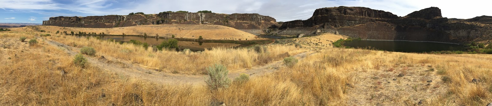 |
| 270° panorama of Potholes Coulee showing "ancient" lakes less than 70 years old, grass-covered flood bars ~15,000 years old, and layers of basalt ~15 million years old. (Ralph Dawes photo) |
From Babcock Bench to the Ancient Lake end of Potholes Coulee, we were walking on a flood bar, an elongate mound of sediment that the flowing water had strewn and piled up along the length of the coulee. Andy Bach and his students have dug into this flood bar and found that just a few feet down are coarser flood sediments, including boulders up to two feet across. Andy thinks the surface layer of finer sediment on the bar is from the last flood that flowed over the bar, a relatively small flood. The coarser sediment hidden underneath, which contains the bigger boulders, is from one or more of the earlier, bigger floods.
The horizontal lines on the sides of the flood bars, alongside the pothole lakes, caught my attention. At first, I wondered if these could be left from the last floods that filled and then drained out of the coulee. Then I realized that they are one of the human imprints on the coulee. They are strand lines left along the shore of a deeper lake that filled the eastern half of Potholes Coulee in the 1950s, when the Columbia Irrigation Project first started channeling irrigation return water from Quincy Basin into the coulee.
 |
| Strand lines preserving a record of temporary lake shoreline levels on side of a flood bar in Potholes Coulee. (Cheryl Dawes photo) |
 |
| Strand lines across talus from higher stands of "Ancient Lake" in the 1950s (Cheryl Dawes photo) |
On the side of another of the Potholes Coulee lakes, on basalt talus piled up at the base of the coulee wall, we saw some more subtly expressed strand lines marking the same higher lake levels.
Aerial photographs from before the irrigation of Quincy Basin show no lakes, no ponded water, and no streams in Potholes Coulee, only dry depressions.
The 1954 aerial photograph below, taken after irrigation began, shows the largest extent of the irrigation water lake that filled much of the coulee then. After 1954, as the lake dropped to a lower level, it stood at each level for a while. This created the strand lines, which mark where its temporary shores were, like rings on the side of a bathtub.
 |
| 1954 aerial photo looking ENE across Potholes Coulee. (Lillquist, 2017, figure 25, page 31. Originally published in Bretz, 1959.) |
When most of the bottom of Potholes Coulee was covered by the irrigation-water lake, the plants on the floor of the coulee died. Since the lake shank into the remaining ponds, the plant growth has not recovered. Most noticeable is the absence of big sagebrush in most of the bottom of the coulee. The sparse plant cover makes it easy to walk off trail in this portion of Potholes Coulee, a contrast with the more typical sagebrush-covered ground nearby.
I made a profile of the surface of the coulee using Google Earth (below). The profile is the red graph at the bottom. The profile follows the elevation of the ground along the red line shown on the map. The near-vertical cliff of the dry cataract at the east end of the coulee shows up prominently near the right (east) end of the profile. The profile crosses a plunge pool at the base of the cataract cliff and a teardrop-shaped basin a short distance west (left) of it.
From the head of the coulee at its east to the high point on its west, the floor of the coulee is covered by flood sediments, which Bretz estimated may reach 200 feet deep. Toward the western end of the coulee, the flood bar sediments pinch out and the underlying basalt bedrock crops out at the surface. Where the basalt begins cropping out, the land slopes down through a scabland of exposed basalt. Farther west, it drops vertically down another set of cliffs that were cut into a deeper layer of the basalt than the cliff at the east end of the coulee. At its west end, the profile reaches flood bars deposited alongside the Columbia River and the Wanapum Lake reservoir.
 |
| Topographic profile along length of Potholes Coulee. (Google Earth, labels added. The 2 km (1.6 mi) white scale bar at bottom right is for the map in the background.) |
The slope of the floor of the coulee raises a question - why does it slope uphill in the downstream direction? Streams usually flow downhill, right? Yes, when you look at the whole stream. Water at the surface of a stream flows up and over a partly submerged boulder. In pools in channels of rivers and streams, the bottom-water flows up out of the pool at its downstream end. Given the scale of the floods at Potholes Coulee, the coulee may have simply been a pool in the stream.
 |
| In the 1950s, the lakes below the dry cataract at the head of the coulee were a single, deeper lake, filled by irrigation water. Looking northwest. (Google Maps, labels added) |
On our hike, as we walked along the megaflood-laid sediment strewn out as a flood bar down the middle of the coulee, we didn't notice the "giant current ripples" on it that show up in Google satellite images. The ripples were formed by the energetic flow of water over the floor of the coulee during the last big flood that passed through. The "giant current ripples" in Potholes Coulee are not very giant, not nearly as big and obvious as those on much larger flood bars in other parts of the channeled scablands.
The ripples on the flood bar in Potholes Coulee are about a foot high. After over 12,000 years of wind and incipient soil development, and after being covered beneath the water of a temporary lake back in the 1950s, the ripples on the surface of the flood bar have lost some of their definition and are hard to see when you are in Potholes Coulee, unless the light is just right and your viewpoint advantageous. Those are my excuses for not spotting them when I was there!
Can you see the ripples in this Google Maps image?
 |
| (Google Maps, label, arrows added) |
Floods of another substance are responsible for the bedrock of Potholes Coulee - the multiple floods of basaltic lava that flowed across the region, millions of years ago. These flows cooled and solidified to form a pile of layers of bedrock known as the Columbia River Basalt province. This province is huge. Some of its lava flows are over a hundred feet thick, cover parts of Idaho, Oregon, and Washington, reach through the Columbia Gorge, and go part way into the Pacific Ocean along the shores of Oregon. The Columbia River Basalt province is one of a small number of continental flood basalt provinces in the world.
The floods of basaltic lava and the floods of ice-age meltwater are completely different things, and happened at completely different times. The lava flows seen in Potholes Coulee erupted more than ten million years ago. The ice-age megafloods happened millions of years later, after the world had cooled considerably and continental glaciers had developed over large parts of North America, ending only 12,000 years ago.
You can see two Columbia River basalt flow groups in Potholes Coulee. The Grande Ronde Formation (15.6-16.5 million years old) and the Wanapum Formation (14.5-15.6 million years old). When we walked on Babcock Bench and the floor of Potholes Coulee, the bedrock beneath our feet was the Grande Ronde Formation. We were looking at the Wanapum Formation in the cliffs that form the walls of Potholes Coulee.
 |
| Two members (flows or flow groups) of the Wanapum Formation of the Columbia River Basalt Group form the walls of Potholes Coulee, the Frenchman Springs Member and the Roza Member. The Roza flow is particularly well known to geologists and rock climbers - note the broad, tall columns in its colonnade. (Ralph Dawes photo) |
The erosion of basalt flows by megafloods is a key to understanding the channeled scablands. As the basalt cools, it shrinks, making cracks in the rock, which geologists call joints. Different joint patterns define a typical Columbia River basalt flow. The base of a flow is a colonnade consisting of vertical columns of rock, separated by elongate joints. The colonnade is topped by an entablature, a more cohesive layer that lacks the vertical columns. The continuous voids created by the elongate joints between columns make the colonnade vulnerable to the powerful flows of water. During erosion of a Columbia River basalt flow by a megaflood, first the columns were plucked from beneath. This undermined the entablature so that large pieces of it collapsed.
This step-wise erosion of the basalt by megafloods created vertical cliffs with overhangs and ledges, and flat-bottomed coulees. The flows with thick, strong entablatures held up longer, making cliffs where exposed, flooring and holding up benches and flat areas where erosion did not excavate down into the resistant entablature level, and the flows above, with lots of weak colonnade layers, eroded away.
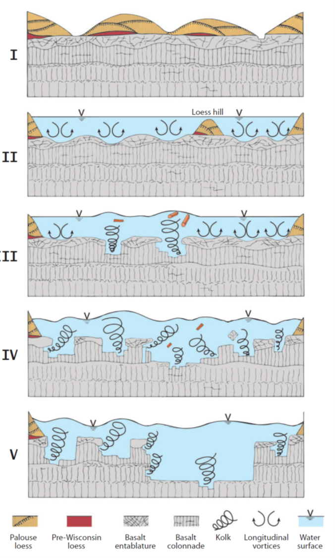 |
| I find this useful in visualizing how the channeled scablands eroded (Baker, 2009). Loess is wind-blown silt that accumulated on top of the basalt. |
If it were not for the structure of the Columbia River basalt flows, with their unusual thickness and widespread, repeated sequences of colonnades and entablatures, the channeled scablands would not have their distinctive character, their scablands cut by steep-walled coulees. In peripheral zones around the Columbia River province where the megafloods eroded into granitic and metamorphic rock, the valleys are more rounded and the relatively flat scabland areas are missing.
 |
| (Cheryl Dawes photo) |
On our way out of Potholes Coulee, a denizen of the near-desert climate eyed us from a boulder along the trail. We also saw signs of deer and coyote on the trail, reminding us of the variety of life to be found in this setting.
After leaving Potholes Coulee, we drove around on the White Trail Road and entered the Quincy Lakes access, just above and to the east of Potholes Coulee. A short walk from the roadside, by Evergreen Lake, brought us to the rim of the southern arm of Potholes Coulee, which contains Dusty Lake. As mentioned above, Potholes Coulee is actually a double coulee, thought to have been formed by a double cataract with a ridge in between.
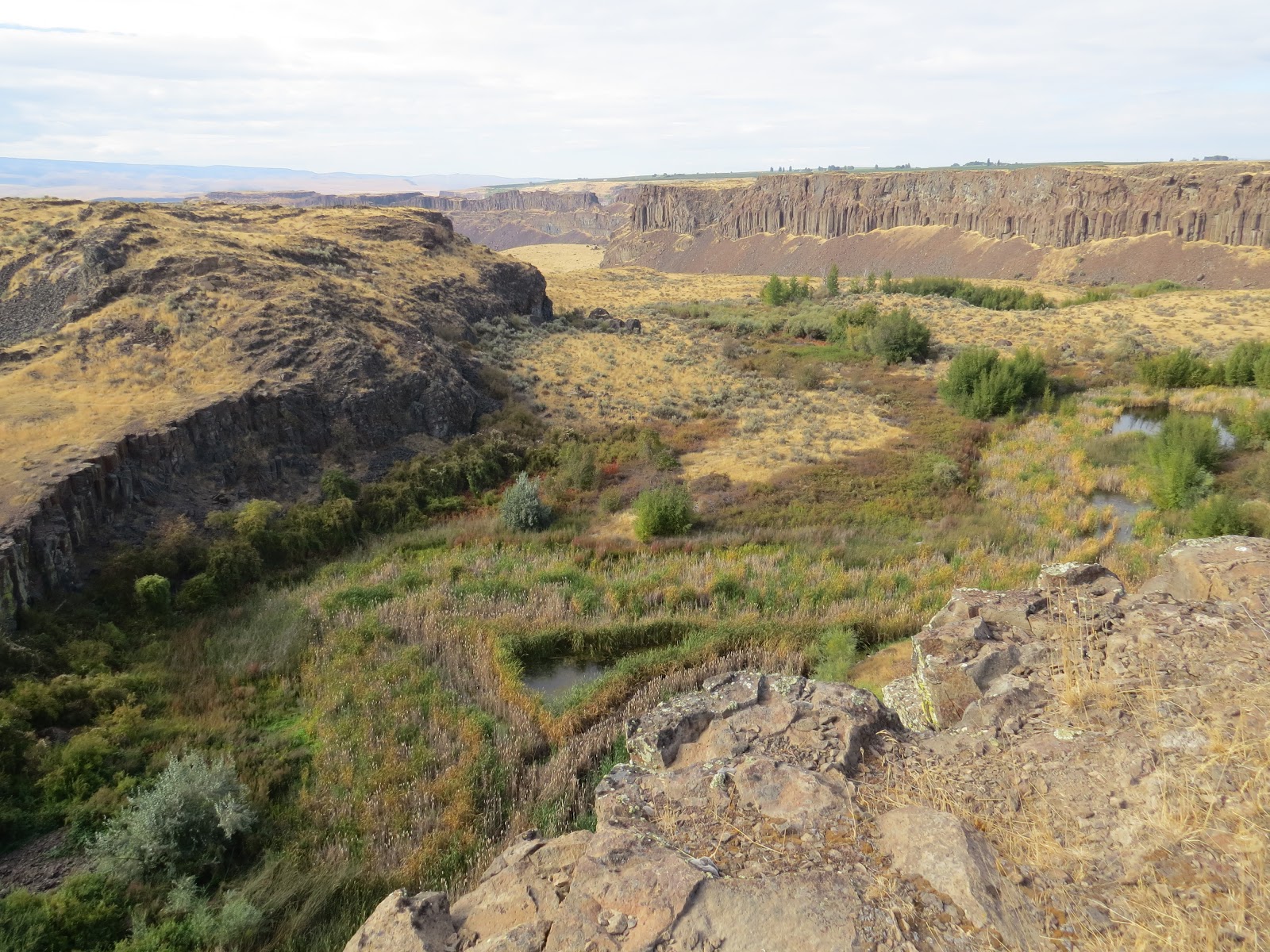 |
| Looking over the cataract cliff into southern branch of Potholes Coulee. Dusty Lake is on the floor of the coulee, hidden behind the cliff on the left side. (Cheryl Dawes photo) |
Here we had a deep view from the top of the dry cataract that drops over a cliff into the southern alcove of Potholes Coulee, which contains Dusty Lake. We could see how the raised water level from irrigation runoff interacted with the plunge pool below the vanished waterfall to make wetlands that supported a diverse array of plants and animals.
Along the northern edge of this part of the coulee, the blade features an outstanding colonnade, in the Roza Member of the Columbia River Basalt. And with that, we called it an end to a good day's excursion in which we explored the geology of Potholes Coulee.
 |
| (Cheryl Dawes photo) |
References
- Baker, V. R. (1978). Paleohydraulics and hydrodynamics of Scabland floods.: In The Channeled Scablands: A Guide to the Geomorphology of the Columbia Basin, Washington. PNASA: Comparative Planetary Geology Field Conference held in the Columbia Basin, June 5-8, 1978, edited by V.R. Baker and D. Nummedal.
- Baker V.R. (2009). Channeled Scablands: A Megaflood Landscape. In Migon P. (eds) Geomorphological Landscapes of the World. Springer, Dordrecht.
- Baker, V.R. (2009). The Channeled Scabland: A retrospective. Annual Reviews of Earth and Planetary Sciences 37: 6.1-6.19.
- Baker, V. R., & Kale, V. S. (1998). The role of extreme floods in shaping bedrock channels. In Rivers over rock: Fluvial processes in bedrock channels, edited by Tinkler, K. J., & Wohl, E., American Geophysical Union monograph series, No. 107, p. 153-165.
- Bjornstad, B. (2004) GCKT9Z Potholes Coulee (Traditional Cache) on Geocaching web site.
- Bjornstad, B. and E. Kiver (2012). On the Trail of the Ice Age Floods: The Northern Reaches. Keokee Company Publishing, Inc. Sandpoint, ID.
- Bretz, J Harlen (1923). The channeled scablands of the Columbia Plateau. The Journal of Geology 31, no. 8: 617-649.
- Bretz, J H. (1959). Washington’s Channeled Scabland. Washington Division of Mines and Geology Bulletin 45.
- Gulick, C.W. (1990). Geologic map of the Moses Lake 1: 100,000 quadrangle, Washington. Washington State Department of Natural Resources, Division of Geology and Earth Resources.
- Lillquist, Karl (2017). Western Quincy Basin Field Trip. Ice Age Floods Institute (Ellensburg Chapter), Western Quincy Basin Field Trip 04 17 2017.pdf.
- Mueller, Marge and Mueller, Ted (1997). Fire, Faults and Floods – A road and trail guide exploring the origins of the Columbia River Basin. Univ. of Idaho Press.
- O'Connor, J.E. and Costa, J.E. (2004). The world's largest floods, past and present: their causes and magnitudes. US Geological Survey Circular, vol. 1254.
- Reidel, Stephen; Camp, Victor, S.; Martin, Barton, L.; Tolan, Terry; Wolff, J. (2016). The Columbia River Basalt Group of western Idaho and eastern Washington - Dikes, vents flows, and tectonics along the eastern margin of the flood basalt province. 127-150. 10.1130/2016.0041(04).
- Russell, I. C., (1893). A Geological Reconnaissance in Central Washington. U. S. Geol. Survey Bull. 108.
- Schwennesen, A.T., and Meinzer, O.E. (1918). Ground Water in Quincy Valley, Washington. US Government Printing Office.
- Symmons, T. W., (1882). Report of an examination of the upper Columbia River. 47th Cong., 1st sess., S. Ex. Doc. 186.
- Tabor, R. W., Waitt Jr, R. B., Frizzell Jr, V. A., Swanson, D. A., Byerly, G. R., & Bentley, R. D. (1982). Geologic map of the Wenatchee 1: 100,000 quadrangle, central Washington. U.S. Geological Survey.
Fascinating! Thank you for the insight on an area that I've visited many times. Did you see the boulders I mentioned in my class discussion in PNW geology?
ReplyDelete