
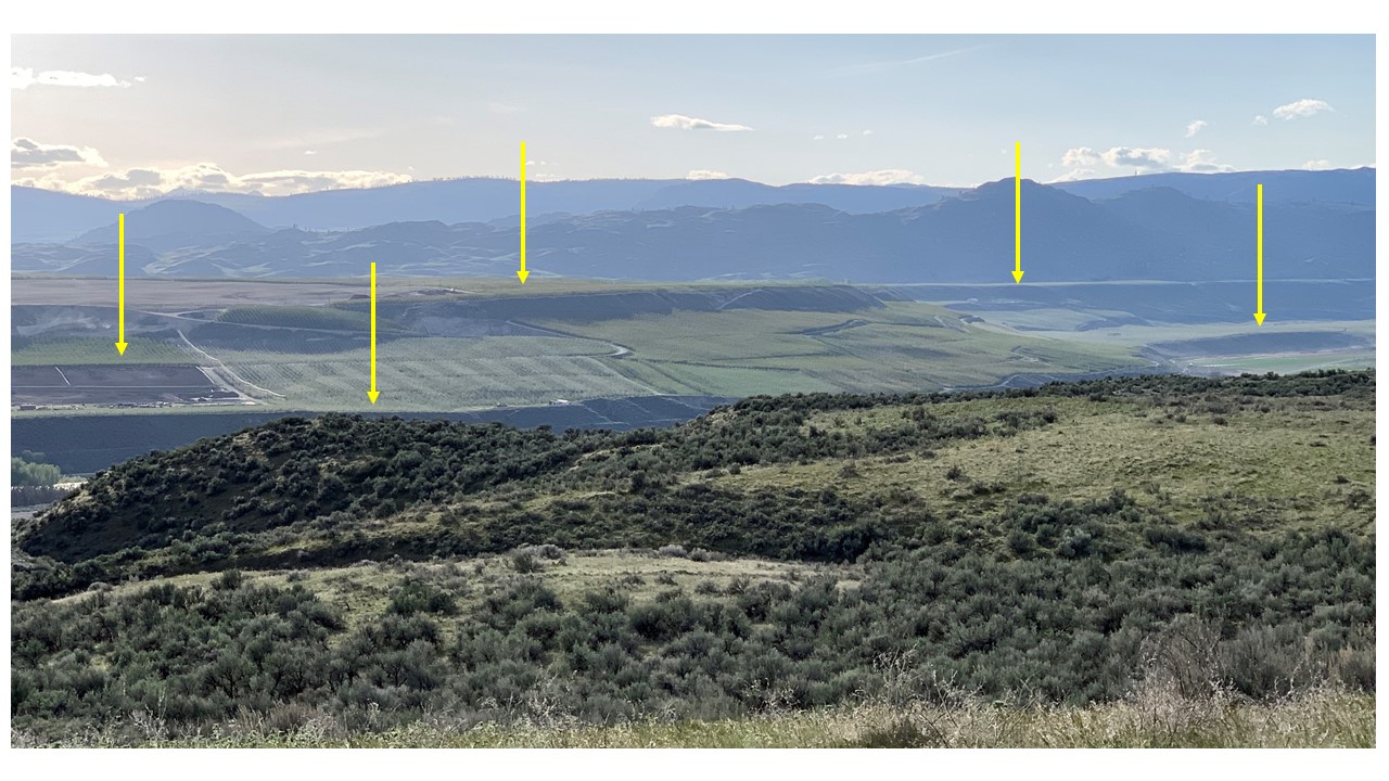 |
| Glacial outwash plains (arrows) largely covered by apple orchards in the lower Okanogan Valley northeast of Brewster, Washington. |
Based on my reading and discussions with other geologists, I know that questions persist about the glaciation of the Okanogan region, including whether it generated giant subglacial floods that eroded the Okanogan landscapes and contributed to the erosion of the coulees and scablands to the south. There is more we need to learn about the glaciation of the Okanogan region if we are to understand the history of the ice sheet in the area, how it created the landforms that distinguish the region, and the role of meltwater.
Alpine glaciers are relatively small, localized glaciers, commonly forming on individual mountains and confined to valleys. Mount Rainier and other high peaks in the Cascade Mountains still have alpine glaciers on them. In the increasingly warm climate of the modern era, they are all shrinking.
Ice sheets, in contrast, are orders of magnitude larger than alpine glaciers. Ice sheets cover large portions of continents and flow across mountain ranges. At its largest, the Cordilleran ice sheet covered the Coast Range and Rocky Mountains of western Canada and the plateaus between the mountain ranges. It was similar in size to the modern-day Greenland ice sheet.
The Cordilleran ice sheet formed and then melted away several times in the last three million years, possibly more than ten times. The Cordilleran ice sheet last reached its maximum size approximately 17,000 years ago. It then melted away in a warming climate, retreating north into Canada by about 14,000 years ago. Its last remnants up north finished melting away by 11,000 years ago.
A large lobe of the Cordilleran ice sheet, the Okanogan lobe (see map below), flowed south across the Okanogan region of eastern Washington and out onto the Columbia Plateau. It dammed the Columbia River for at least several hundred years during the last glacial maximum.
We don't yet fully understand the details of the Okanogan lobe. How thick was the ice across the Okanogan region? Did the ice sheet have zones of extremely rapid flow while moving much slower elsewhere? What role did water beneath and beyond the glacier play? And did any of the mountains in the Okanogan region grow their own alpine glaciers when the ice sheet was not present?
To begin answering these questions, I am investigating a selection of four high peaks on either side of the Okanogan Valley to see whether they were overtopped by the Cordilleran ice sheet. Or did they protrude above the ice sheet, which would make them nunataks?
 |
| From Booth, Derek B., Kathy Goetz Troost, John J. Clague, and Richard B. Waitt, 2003, The Cordilleran ice sheet, Developments in Quaternary Sciences, 2003, no. 1, p. 18, Fig. 1, "Map of southern extent and lobes of the latest Pleistocene advance of the Cordilleran ice sheet in Washington and British Columbia." |
We don't yet fully understand the details of the Okanogan lobe. How thick was the ice across the Okanogan region? Did the ice sheet have zones of extremely rapid flow while moving much slower elsewhere? What role did water beneath and beyond the glacier play? And did any of the mountains in the Okanogan region grow their own alpine glaciers when the ice sheet was not present?
To begin answering these questions, I am investigating a selection of four high peaks on either side of the Okanogan Valley to see whether they were overtopped by the Cordilleran ice sheet. Or did they protrude above the ice sheet, which would make them nunataks?
 |
| Picture of a nunatak sticking out of the Greenland ice sheet. (From Tasermuit.) |
Determining whether any of these peaks were nunataks even when the ice sheet was at its maximum thickness will help constrain the thickness and shape of the ice sheet. Signs of alpine glaciers on these peaks, and whether any of the alpine glaciation took place after retreat of the ice sheet, will help pin down the climate history of the region beyond the last time the ice sheet covered the area.
In focusing on these four peaks, I am leaving aside for now questions that are better addressed by investigating the lower-elevation plateaus and valleys of the region, including whether any Okanogan landforms signify extremely fast-flowing streams of ice within the ice sheet, and whether gigantic, landscape-sculpting floods could have occurred beneath the ice sheet. I hope to write about those topics, and what my explorations tell me about them, in the future.
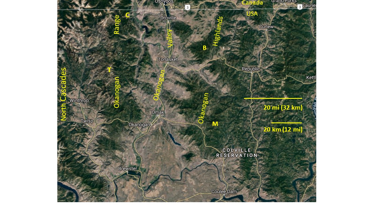 |
| Map showing the four mountains I have targeted on either side of Okanogan Valley: M = Moses Mountain, B = Mount Bonaparte, T = Tiffany Mountain, C = Chopaka Mountain. Each targeted peak is the highest for over 20 km in all directions, except Chopaka, which has peaks rising to higher elevations within 20 km to the north and west, beyond the Okanogan Range. (Yellow labels added to Google Maps image.) |
According to my investigation of Moses Mountain:
- Moses Mountain was covered by the Cordilleran ice sheet.
- When the ice sheet was not present, an alpine glacier eroded a U-shaped valley northeast of the peak of Moses Mountain.
The evidence I observed on Moses Mountain is what the rest of this blog post is about. I will report my results from Mount Bonaparte, Tiffany Mountain, and Mount Chopaka in subsequent blog posts.
However, I have decided to toss in some spoilers here: Like Moses Mountain, Mount Bonaparte was covered by the ice sheet. But Tiffany Mountain was a nunatak! It protruded many hundreds of feet above the ice, and some nearby peaks were also nunataks. Tiffany Mountain presents a classic suite of evidence of having been a nunatak, which I look forward to sharing in my blog.
However, I have decided to toss in some spoilers here: Like Moses Mountain, Mount Bonaparte was covered by the ice sheet. But Tiffany Mountain was a nunatak! It protruded many hundreds of feet above the ice, and some nearby peaks were also nunataks. Tiffany Mountain presents a classic suite of evidence of having been a nunatak, which I look forward to sharing in my blog.
 |
| Map showing southern part of Cordilleran ice sheet at its last glacial maximum, including the Okanogan lobe. Added letter labels show approximate locations of the four peaks I have chosen to investigate: M = Moses Mountain, B = Mount Bonaparte, T = Mount Tiffany, C= Mount Chopaka. (Map from Wikiwand article on Glacial Lake Columbia.) |
At 6,774 ft (2,065 m) above sea level, Moses Mountain is over 1,000 ft (300 m) taller than any other peak within 15 miles (24 km) and is the high point of the southern Okanogan Highlands. Despite its height, it does not stand out as a jagged peak. It has a smooth, rounded profile.
 | |
|
Higher on the mountain, glacial till becomes pervasive, up to 10 ft (3 m) or so thick, with granite boulders up to several meters wide buried in it and scattered here and there on its surface.
 |
| Probable glacial till with large boulders on Moses Mountain. All, or nearly all, of the boulders are Moses pluton rocks, which is what Moses Mountain is made of. Therefore, even though the boulders were probably plucked and transported by the Cordilleran ice sheet, most of them were not transported very far. |
All of Moses Mountain's solid bedrock, beneath the loose sediments that cover most of its surface, has been mapped as granite and granodiorite of the Moses pluton. A pluton is a body of rock that intruded the Earth's crust and solidified deep beneath the surface. Nearly all the boulders I saw in the till looked like pieces of Moses pluton, including the large potassium feldspar crystals and biotite as the black mineral.
 |
| Moses pluton biotite granite with a few of it characteristic larger potassium feldspar crystals in a medium-grained matrix. |
Towards the top of the mountain the dirt road got rough, partly because recent heavy rainstorms had deepened gulleys and exposed boulders and rock ledges in the roadbed.
A roadcut by a hairpin turn at 6,000 ft (1,830 m) elevation revealed deeply weathered Moses pluton granite directly underlying the diamicton that I am interpreting as glacial till. Diamicton is the term for an unsorted deposit of rock debris ranging from boulders to fine sediment. Glacial till is a type of diamicton that is deposited directly from the ice of a glacier.

The granite bedrock is weathered to the bottom of the exposure. The granite was so corroded that I could kick pieces of it apart with my boot and break pieces of it apart in my hands. It is well on its way to becoming grus, which is sand made of feldspar and quartz grains that have weathered out of local bedrock. The weathering has chemically altered the minerals in the granite into slightly darkened colors, in contrast with the boulders of less weathered granite from the overlying diamicton.
My interpretation is that the deeply weathered profile in the granitic bedrock developed prior to the arrival of the Cordilleran ice sheet and that the ice sheet covered it with a thin veneer of till and boulders during its last glacial maximum around 17,000 years ago.

Looking around at the loose material that covers upper Moses Mountain, I found boulders perched on top of other boulders. The boulders are relatively fresh granite, not anywhere near as weathered as the weathered bedrock seen in the roadcut. This minimal to moderate stage of weathering of the granite boulders is typical of boulders in till from the end of the last ice age (Pleistocene epoch) glaciation.

My rock hammer rang when it hit the surface of these fresh boulders, and the head of the hammer bounced back with lots of spring. This is consistent with the possibility that most boulders were transported far enough by the glacier, and scraped with enough energy, that it removed weathered and partly decomposed rock material that had accumulated prior to the ice sheet's arrival. The glacier cleaned off the weathered surfaces and freshened the rocks into their bright-white original granitic selves.
The deposit mantling the surface of upper Moses Mountain, which I am interpreting as glacial till, has a matrix of sand, silt, and clay, a matrix that supports the angular to sub-rounded cobbles and boulders. The till is relatively loose, not tightly packed.
 As I arrived at the peak, I could see that the lookout tower on top reached all the way up into the thin clouds, living up to its reputation as the tallest lookout tower in the state.

After walking around and looking closely at the ground, avoiding areas that had been affected by bulldozing, roadbuilding, and construction, I concluded that there is glacial till on top of Moses Mountain.

The rocky debris covering the top of Moses Mountain appears similar to the diamicton observed on the mountain a few hundred feet below the summit. Most prominent are the countless boulders of white granitic rock standing out above the ground, with more or less rounded, rather than highly angular, shapes. Only a very thin veneer of weathering has affected the surfaces of the boulders, so lightly on some surfaces that it's hard to see it as other than freshly exposed granite.
Parts of some boulders have thin layers of dark lichen growing their surfaces, contrasting with the otherwise white rock exteriors. I saw a few boulders with concave tops where water pooled, causing dissolution and weathering pits to form, up to a few tens of inches across and a couple of inches deep.
I describe these details to accurately convey the extent of weathering of the granite boulders on top of Moses Mountain. The patches of lichen and the weathering pits on the boulders are not out of line with the boulders having been placed in their current position, exposed at the Earth's surface, near the end of the Pleistocene epoch, roughly 15,000 years ago. The weathering marks are not pervasive and deep enough to suggest weathering since much longer ago than that. These are still relatively fresh boulders
 On the summit of the mountain are numerous examples of boulders placed on top of other boulders.
The boulders in a single stack don't always match each other in how parallel their mineral orientations are and what their bulk percentages of dark minerals are, suggesting they have been moved out of place.

The boulder-studded diamicton on the peak of Moses Mountain, which I am interpreting as glacially deposited, is thin, only about a meter thick on much of the mountaintop (not counting how high above it the boulders protrude). In some places the bedrock underneath shows through.
The exposed bedrock that I saw at the summit lacks the deeply-weathered profile of discolored, weakened, partly grusified granite I saw alongside the road at 6,000 ft (1,830 m) elevation, nearly 800 ft (244 m) below the peak. It may be that abrasion and plucking by moving glacial ice removed any deeply weathered bedrock from the summit of Moses Mountain, but in some other places did not erode the upper layer of weathered bedrock. The same sort of variations in how much the old, weathered bedrock surfaces were eroded away by the ice sheet have been reported from the interior of British Columbia.
Several hundred feet below the top of Moses Mountain, I took one last picture, showing how the till thickens, on average, as elevation declines. At the top center of the photograph is one of the "erratic" boulders standing out above its surroundings, which I saw at all elevations on the mountain and are typical of glaciated landscapes. My interpretation is that it was left in that position by the Cordilleran ice sheet, along with the rest of the boulders on the mountain, including the ones on the peak.

Conclusion: The ice sheet covered the top of Moses Mountain.
Did any alpine glaciers form on Moses Mountain before or after the last Cordilleran ice sheet maximum? On this matter, I have only examined evidence on maps and satellite images, which suggests Moses Mountain may have had an alpine glacier or two on its upper north side.
Whether any such glaciers were active after the Cordilleran ice sheet was last there cannot be determined from the maps, and I did not go to that part of the mountain myself.
 | |
|
 |
| Stepstone Creek valley on the northeast side of Moses Mountain looks like a U-shaped valley. (Google Maps image.) |
Stepstone Creek valley, on the northeastern side of the mountain, looks U-shaped in its cross-valley topographic profile. There are also some shallower valleys on the upper northwest side of Moses Mountain that look somewhat U-shaped, but they are not as fully trough-shaped as upper Stepstone Creek valley. The growth of alpine glaciers is favored on the northern and eastern slopes of peaks, where the sun shines weaker and the snow melts less. The locations of the possibly alpine glaciated valleys on Moses Mountain are on the northeast and northwest edges of the peak.
No other peak within 15 miles (24 km) of Moses Mountain has any U-shaped troughs suggestive of erosion by an alpine glacier and none of the nearby peaks are over 5,500 ft in elevation. This suggests that the minimum elevation needed in that area for alpine glaciers to form may have been approximately the elevation of Moses Mountain, around 6,700 ft (2,000 m).
I get the impression from looking at satellite photos on Google Maps that if there were any alpine glaciers in any of the valleys on the north side of upper Moses Mountain, they existed prior to the Cordilleran ice sheet, not after, because there are no obvious terminal, recessional, or lateral moraines. Moraines are piles of glacial till and each type of moraine forms a specific pattern on a landscape. If there were any moraines left on Moses Mountain by alpine glaciers prior to the last glacial maximum, the Cordilleran ice sheet would likely have flowed across, eroded, deposited on, and in general, obscured them, while leaving U-shaped alpine glacial troughs intact.
Because Google Maps and Google Earth imagery are low-resolution, it would take traversing and mapping on foot to see if there are more definitive signs of alpine glaciation in the valleys north of the peak. Pending such an investigation, my suggestion that there were one or more alpine glaciers on Moses Mountain is tentative and my impression that they formed prior to the last time the ice sheet covered the area, and not after, is speculative.
Menounos and others, in a recent paper (2017, "Cordilleran ice sheet mass loss preceded climate reversals near the Pleistocene termination," Science, vol. 358, issue 6364, pp. 781-784) have found evidence that numerous alpine glaciers formed in cirques and valleys at high elevations in the interior of British Columbia, after the ice sheet had melted from the heights.
On the basis of their age measurements, Menounos and others argue that this spurt, or possibly two spurts, of alpine glaciation occurred between 15,000 and 12,000 years ago, soon after the Cordilleran ice sheet had melted from those locations. They correlate the growth of post-ice-sheet alpine glaciers with global climate cooling events that are thought to have caused ice sheet re-advances in some locations and growth of alpine glaciers in others.
The minimum elevation at which alpine glaciers can form in the mountains of the western United States and Canada rises as one goes east (inland) and south, because of the lower amount of snow that falls farther from the ocean and the warmer temperatures as one goes south. Moses Mountain is located approximately a hundred miles south and east of the places that Menounos and others found evidence of post-ice-sheet alpine glaciers.
Therefore, it may be that the elevation at which alpine glaciers could form after the last glacial maximum - after about 15,000 years ago - was above the elevation of Moses Mountain, but was not above the elevation of the mountain prior to the Okanogan lobe forming.
This suggests the possibility that alpine glaciation on Moses Mountain occurred during what is known as the Evans Creek stade, climaxing about 21,000 years ago, when alpine glaciers in the nearby Cascade Mountains are known to have reached a maximum and then retreated. This was prior to the last advance of the Cordilleran ice sheet across the Okanogan region.
Further investigation would be needed to resolve whether Moses Mountain had any alpine glaciers, and if so, when.
Getting back to my conclusion that Moses Mountain was underneath the ice sheet, this has some bearing on interpretations of the thickness and shape of the Okanogan lobe. Let's look at one example.
My results from Moses Mountain can be compared with two theoretical ice-surface profiles across the southern part of the Okanogan lobe (below). The profiles are labeled "Waitt & Thorsen (1983)" and "Kovanen & Slaymaker."
The profiles show the shape of the ice sheet surface along a line on a map. Below the ice sheet profiles, in gray, is a topographic profile of the land surface beneath the glacier. You can see from the steepness of its peaks and valleys that the vertical scale of the profiles is greatly exaggerated relative to the horizontal scale.
The profiles are along a line on a map that starts on its northern end (left side of diagram) about 3 miles (5 km) south and 12 miles (20 km) west of Moses Mountain.
To cover Moses Mountain, the Cordilleran ice sheet would have been at least 2,065 m above sea level, the elevation of the top of the mountain. Therefore, if my conclusion that the ice sheet overtopped Moses Mountain is correct, Kovanen and Slaymaker's profile may be at much too low an elevation at its northern end.
It looks like my investigation of which of the tallest peaks around the Okanogan Valley were overtopped by the Cordilleran ice sheet is beginning to bear some fruit. My results from the remaining three peaks will be reported in future posts.
Further investigation would be needed to resolve whether Moses Mountain had any alpine glaciers, and if so, when.
Getting back to my conclusion that Moses Mountain was underneath the ice sheet, this has some bearing on interpretations of the thickness and shape of the Okanogan lobe. Let's look at one example.
My results from Moses Mountain can be compared with two theoretical ice-surface profiles across the southern part of the Okanogan lobe (below). The profiles are labeled "Waitt & Thorsen (1983)" and "Kovanen & Slaymaker."
The profiles show the shape of the ice sheet surface along a line on a map. Below the ice sheet profiles, in gray, is a topographic profile of the land surface beneath the glacier. You can see from the steepness of its peaks and valleys that the vertical scale of the profiles is greatly exaggerated relative to the horizontal scale.
 |
| From Kovanen, Dori J., and Slaymaker, Olav, "Glacial imprints of the Okanogan Lobe, southern margin of the Cordilleran Ice Sheet." Journal of Quaternary Science vol. 19, issue no. 6 (2004). pp. 547-565; Fig. 13, p. 561. |
The profiles are along a line on a map that starts on its northern end (left side of diagram) about 3 miles (5 km) south and 12 miles (20 km) west of Moses Mountain.
To cover Moses Mountain, the Cordilleran ice sheet would have been at least 2,065 m above sea level, the elevation of the top of the mountain. Therefore, if my conclusion that the ice sheet overtopped Moses Mountain is correct, Kovanen and Slaymaker's profile may be at much too low an elevation at its northern end.
It looks like my investigation of which of the tallest peaks around the Okanogan Valley were overtopped by the Cordilleran ice sheet is beginning to bear some fruit. My results from the remaining three peaks will be reported in future posts.
Comments
Post a Comment